


The NUFBUS is coming!
Just got in by the skin of our teeth!
See you there.
Southern Softies Weekend
Moderator: Jillygumbo
-
Pete & Sue

- Tribal Elder
- Posts: 649
- Joined: Tue Jan 16, 2007 10:37 am
- Location: Ashford, Kent
-
Mrs Handyman
-
Dago & Mrs D
- Supreme Being
- Posts: 1341
- Joined: Mon Aug 08, 2005 9:41 pm
- Location: Eastbourne, East Sussex
- Contact:
-
crazy uncle gray g
- Supreme Being
- Posts: 1695
- Joined: Tue Mar 14, 2006 8:38 pm
- Location: new forest
Dago & Mrs D wrote:Hey Pete and Sue - get to meet at lastBest we put labels on our respective Petes and Bongos in case we get them mixed up
Be interesting to see if they look as alike in the flesh as their pics

Mrs. D
We dont want no mix ups on camp. OH ! missus.
cheers! party on dudes.

-
francophile1947
- Supreme Being
- Posts: 11354
- Joined: Mon Dec 18, 2006 6:15 pm
- Location: Norwich
Extract from their website:-
Bay View Park is a Holiday Home, Touring and Camping Park, situated at the end of a private road on the beautiful Sussex coast, just yards from the beach with sweeping panoramic views of Pevensey Bay and its Sailing Club.
Take ya ring pull detector gal
Bay View Park is a Holiday Home, Touring and Camping Park, situated at the end of a private road on the beautiful Sussex coast, just yards from the beach with sweeping panoramic views of Pevensey Bay and its Sailing Club.
Take ya ring pull detector gal
John
(Evidence that intelligent life exists in the universe, is that it hasn't tried to contact us)
(Evidence that intelligent life exists in the universe, is that it hasn't tried to contact us)
-
Dago & Mrs D
- Supreme Being
- Posts: 1341
- Joined: Mon Aug 08, 2005 9:41 pm
- Location: Eastbourne, East Sussex
- Contact:
Tigs, it is all but ON the beach  . The beach is pebbles except at low tide. At the moment we don't have a tide table to see when high and low tides will be in April but we'll let you know as soon as we have.
This is the approach to the campsite reception - main site to the left, Bongo field to the right (behind Dago). The beach is just behind the white house at the end of the lane.

This is from standing on the bank at the end of the camping field looking west towards Eastbourne
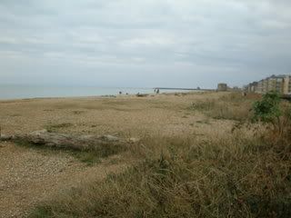
This is from the main field looking east towards Hastings with Pevensey Bay Sailing Club next door.
[/img]

There are two or three walks that we could organise (to depend on the weather):
1. Across the fields to Pevensey Castle and a pub - about 2miles but could do a further circular walk the other side of the castle before retiring to the pub if people are really keen
2. Along the top edge of the beach, across the lock gates to the restaurants/pubs at Sovereign Harbour (about a mile and a half via tarmac footpath at top of beach) from where the path turns into the promenade to Eastbourne (a further 2 miles)
3. Along the beach in the other direction to Pevensey Bay village (and, guess what . . . another pub!!) - not far but more difficult walking on the pebbles.
We were going to try the field walk this weekend if the sun shines and it's not too muddy under foot.
Mrs. D
This is the approach to the campsite reception - main site to the left, Bongo field to the right (behind Dago). The beach is just behind the white house at the end of the lane.
This is from standing on the bank at the end of the camping field looking west towards Eastbourne
This is from the main field looking east towards Hastings with Pevensey Bay Sailing Club next door.
[/img]
There are two or three walks that we could organise (to depend on the weather):
1. Across the fields to Pevensey Castle and a pub - about 2miles but could do a further circular walk the other side of the castle before retiring to the pub if people are really keen
2. Along the top edge of the beach, across the lock gates to the restaurants/pubs at Sovereign Harbour (about a mile and a half via tarmac footpath at top of beach) from where the path turns into the promenade to Eastbourne (a further 2 miles)
3. Along the beach in the other direction to Pevensey Bay village (and, guess what . . . another pub!!) - not far but more difficult walking on the pebbles.
We were going to try the field walk this weekend if the sun shines and it's not too muddy under foot.
Mrs. D

-
Dago & Mrs D
- Supreme Being
- Posts: 1341
- Joined: Mon Aug 08, 2005 9:41 pm
- Location: Eastbourne, East Sussex
- Contact:
Tried to paste in the link to Multimap with the aerial view of the camp but it doesn't work, however the post code of the site is BN24 6DX.
If you go to http://www.Multimap.com and put the postcode in and choose "aerial" it will show a very old photo as the earthy area on the left of the picture is now all housing and part of the Sovereign Harbour development, but you can see how close the sea is!
If you go to http://www.Multimap.com and put the postcode in and choose "aerial" it will show a very old photo as the earthy area on the left of the picture is now all housing and part of the Sovereign Harbour development, but you can see how close the sea is!
-
francophile1947
- Supreme Being
- Posts: 11354
- Joined: Mon Dec 18, 2006 6:15 pm
- Location: Norwich
Tide Times for Eastbourne (nearest I could get!)
Low High Low High
18th April 05.21 10.59 17.36 23.17
19th April 05.55 11.35 18.11 23.50
20th April 06.29 12.00 18.43 00.22(21st)
Hmmm - it doesn't post like it previews but you should be able to work it out
Low High Low High
18th April 05.21 10.59 17.36 23.17
19th April 05.55 11.35 18.11 23.50
20th April 06.29 12.00 18.43 00.22(21st)
Hmmm - it doesn't post like it previews but you should be able to work it out
John
(Evidence that intelligent life exists in the universe, is that it hasn't tried to contact us)
(Evidence that intelligent life exists in the universe, is that it hasn't tried to contact us)
I particularly like the sound of walk 1. Castle and pub sounds
Are there many young kids going do you know?

 Bonnie cant swim
-
francophile1947
- Supreme Being
- Posts: 11354
- Joined: Mon Dec 18, 2006 6:15 pm
- Location: Norwich
-
Dago & Mrs D
- Supreme Being
- Posts: 1341
- Joined: Mon Aug 08, 2005 9:41 pm
- Location: Eastbourne, East Sussex
- Contact:
Thanks for the tide times francophile. Shame that high tide is around midday, perhaps if it's warm enough on Saturday Evening, we can get our bucket & spades out, on the sand.
Well done tigs for the aerial photo. The Bongo field is the brown/green rectangle at 10 o'clock posistion from the red circle. Next to that and across the entrance road, you can see the other field, which has several caravans etc. parked around the site.
The large expanse of dark water is the 'north harbour' in Sovereign Harbour and the grey roadway to the top left corner, is the main A259 road from Eastbourne to Pevensey Bay. As you approach from either direction, there is a sign board displaying Bay View Caravan Site at the entrance to the approach road, which is that long thin strip of tarmac track heading for the red circle.
The sandy barren area above the camp site, is the sailing club. Although April is early in the sailing season ( we only start back on the water at the end of March at Eastbourne), I am hoping that they might have a social going on, in which case their bar could be open!!
We shall see what we can do